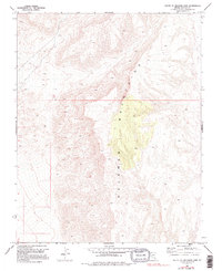
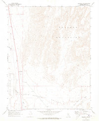
1969 Map of South of Delamar Lake
USGS Topo · Published 1995About this map
The Delamar Mountains dominate this high-desert landscape in Lincoln County, characterized by a series of peaks and complex ridgelines. Based on aerial photography from 1967 and field checks in 1969, the map reveals a terrain primarily defined by natural topography rather than human development. The absence of named settlements, roads, or structures across the quadrangle suggests a remote and unpopulated region of the Great Basin, where the focus remains on the geological formations and the surveyed township lines like T. 8 S. and T. 9 S. that organize this portion of the public land survey system. The intricate contour lines detail the elevation changes between 4,000 and 6,000 feet, providing a precise record of the physical geography before any major contemporary changes were observed during a 1980 photoinspection.
Find a feature on this map
4 named features on this map. Tap any name to fly to it.
Don’t see what you’re looking for? This feature index may not catch every label — zoom into the map to look around manually.
Map Details
Editions of this 1969 South of Delamar Lake Map
3 editions found
Other maps of this area

1885 · Pioche
USGS Topo · 1:250,000

1886 · Pioche
USGS Topo · 1:250,000

1945 · Alamo
USGS Topo · 1:125,000

1954 · Caliente
USGS Topo · 1:250,000

1959 · Caliente
USGS Topo · 1:250,000

1969 · Alamo SE
USGS Topo · 1:24,000
1969 · Delamar 3 SE
USGS Topo · 1:24,000

1969 · Gregerson Basin
USGS Topo · 1:24,000

1969 · Delamar 3 NE
USGS Topo · 1:24,000
1969 · Delamar 3 SW
USGS Topo · 1:24,000