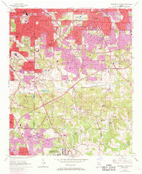
1954 Map of Southeast Atlanta
USGS Topo · Published 1969About this map
Atlanta's southeastern residential expansion and institutional footprint are captured here during a transition from mid-century development to late-1960s urbanization. Dense neighborhoods like Beulah Heights, Ormewood, and Eastland Heights fill the upper reaches of the map, giving way to more dispersed settlements and large tracts of government land further south. The U S Reservation and the sprawling U S Military Reservation (Atlanta General Depot) dominate the lower corridor, highlighting the significant federal and military presence in the region. Local community life is deeply rooted in a network of institutions such as the Thomas Jefferson Sch and numerous faith centers like New Hope Ch and Clifton Ch. Significant landscape features include the winding path of the South River and the industrial-adjacent Constitution Lake, which sit near the junction of Fulton and DeKalb counties.
Find a feature on this map
87 named features on this map. Tap any name to fly to it.
Don’t see what you’re looking for? This feature index may not catch every label — zoom into the map to look around manually.
Map Details
Editions of this 1954 Southeast Atlanta Map
5 editions found
Other maps of this area

1888 · Atlanta
USGS Topo · 1:125,000

1890 · Atlanta
USGS Topo · 1:125,000

1892 · Atlanta
USGS Topo · 1:125,000

1895 · Atlanta
USGS Topo · 1:125,000

1953 · Atlanta
USGS Topo · 1:250,000

1954 · Conley
USGS Topo · 1:24,000

1954 · Decatur
USGS Topo · 1:24,000

1954 · Jonesboro
USGS Topo · 1:24,000

1954 · Riverdale
USGS Topo · 1:24,000

1954 · Bolton
USGS Topo · 1:24,000