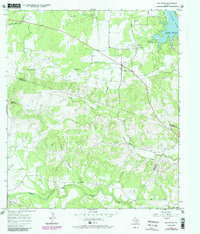
1967 Map of Spicewood
USGS Topo · Published 1987About this map
Spicewood sits at a geographic crossroads in the Texas Hill Country, positioned near the rugged convergence of the Colorado River and the expanding reach of Lake Travis. The landscape is defined by its dramatic relief, moving from the heights of Cedar Mountain and Shovel Mountain down into deeply cut drainages like Fall Creek and Sycamore Creek. This 1967 survey, later updated in the mid-1980s, documents a rural Texas environment where early ranching life and mid-century infrastructure meet.
Find a feature on this map
25 named features on this map. Tap any name to fly to it.
Don’t see what you’re looking for? This feature index may not catch every label — zoom into the map to look around manually.
Map Details
Editions of this 1967 Spicewood Map
4 editions found
Other maps of this area

1887 · Blanco
USGS Topo · 1:125,000

1887 · Burnet
USGS Topo · 1:125,000

1893 · Burnet
USGS Topo · 1:125,000

1894 · Blanco
USGS Topo · 1:125,000

1903 · Burnet
USGS Topo · 1:125,000

1909 · Burnet
USGS Topo · 1:125,000

1925 · Burnet 3-d
USGS Topo · 1:48,000

1929 · Marble Falls
USGS Topo · 1:62,500

1930 · Blanco-1
USGS Topo · 1:48,000

1932 · Marble Falls
USGS Topo · 1:62,500