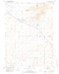
1951 Map of Split Rock
USGS Topo · Published 1978About this map
The Sweetwater River carves through this Central Wyoming landscape, flanked by the massive formations of the Granite Mountains. This 1951 field survey documents a ranching corridor defined by family holdings such as the Mc Intosh Ranch and Split Rock Ranch, where water management was central to survival, as evidenced by the Mc Intosh Beaton Ditch and Cranner Ditch. The presence of the Split Rock School and a CCC Camp (Aban'd) suggests the varied layers of social and government activity in this reach of Fremont County. Notable landmarks like the Great Stone Face and Castle Rock provide fixed points for navigating the high desert terrain, while the remnants of a Grieves Homestead (Aban'd) and Speyers Homestead offer concrete locations for genealogical research into early homesteading efforts along the river valley.
Find a feature on this map
32 named features on this map. Tap any name to fly to it.
Don’t see what you’re looking for? This feature index may not catch every label — zoom into the map to look around manually.
Map Details
Editions of this 1951 Split Rock Map
4 editions found
Other maps of this area

1951 · Bucklin Reservoirs
USGS Topo · 1:24,000

1951 · Lone Mountain
USGS Topo · 1:24,000

1951 · Black Rock Gap
USGS Topo · 1:24,000

1951 · Split Rock
USGS Topo · 1:24,000

1951 · Split Rock NW
USGS Topo · 1:24,000

1951 · Lankin Dome
USGS Topo · 1:24,000

1955 · Casper
USGS Topo · 1:250,000

1958 · Casper
USGS Topo · 1:250,000

1962 · Casper
USGS Topo · 1:250,000

1962 · Whiskey Peak
USGS Topo · 1:24,000