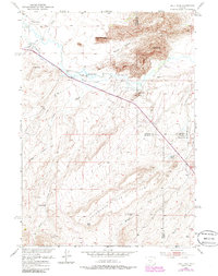
1951 Map of Split Rock
USGS Topo · Published 1985About this map
The Sweetwater River flows through this high desert region of central Wyoming, where the landscape is defined by massive granite outcrops and a network of early cattle ranches. Named landmarks like the Great Stone Face, Split Rock, and Castle Rock tower over the river valley, serving as historic navigational points. This survey, based on 1951 field work with 1980s updates, captures a ranching economy dependent on irrigation systems like the Mc McIntosh Ditch and the Beaton Ditch. Local history is anchored by several established family holdings, including the McIntosh Ranch, Hat Ranch, and Grieves Ranch. The community centered around the Split Rock School, while signs of change appear in the Grieves Homestead (Aband) and Speyers Reservoir (Aband), reflecting the shifting settlement patterns in the shadow of Telephone Line Ridge.
Find a feature on this map
29 named features on this map. Tap any name to fly to it.
Don’t see what you’re looking for? This feature index may not catch every label — zoom into the map to look around manually.
Map Details
Editions of this 1951 Split Rock Map
4 editions found
Other maps of this area

1951 · Bucklin Reservoirs
USGS Topo · 1:24,000

1951 · Lone Mountain
USGS Topo · 1:24,000

1951 · Black Rock Gap
USGS Topo · 1:24,000

1951 · Split Rock
USGS Topo · 1:24,000

1951 · Split Rock NW
USGS Topo · 1:24,000

1951 · Lankin Dome
USGS Topo · 1:24,000

1955 · Casper
USGS Topo · 1:250,000

1958 · Casper
USGS Topo · 1:250,000

1962 · Casper
USGS Topo · 1:250,000

1962 · Whiskey Peak
USGS Topo · 1:24,000