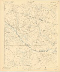
1921 Map of St George
USGS Topo · Published 1921About this map
St George serves as the focal point of this 1919 survey, situated at the junction of the Southern railroad and the historic Augusta Road. The landscape is defined by the winding course of the Edisto River, which creates a natural boundary between Dorchester and Colleton counties. This era reveals a high density of rural social infrastructure, including the Indian Field Campgrounds and numerous denominational anchors such as Jerusalem Church and Green Pond Church. The presence of the Lumber R R and sawmill operations in Badham highlight the importance of the timber industry in the Lowcountry's early 20th-century economy. Smaller hamlets like Reevesville and Grover are clearly mapped alongside a network of one-room schools, including Turkey Pond School and Cattle Creek School, providing a detailed view of the region's decentralized settlement patterns before modern consolidation.
Find a feature on this map
76 named features on this map. Tap any name to fly to it.
Don’t see what you’re looking for? This feature index may not catch every label — zoom into the map to look around manually.
Map Details
Editions of this 1921 St George Map
4 editions found

Other maps of this area

1918 · Walterboro
USGS Topo · 1:62,500

1918 · Cottageville
USGS Topo · 1:62,500

1919 · Ridgeville
USGS Topo · 1:48,000

1919 · Cummings
USGS Topo · 1:62,500

1919 · Lodge
USGS Topo · 1:62,500

1920 · Eutawville
USGS Topo · 1:48,000

1920 · Bowman
USGS Topo · 1:48,000

1920 · Lodge
USGS Topo · 1:48,000

1920 · Ridgeville
USGS Topo · 1:62,500

1920 · Orangeburg
USGS Topo · 1:48,000