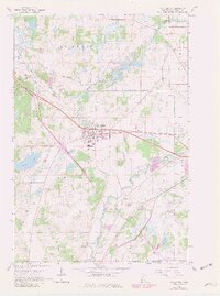
1965 Map of St. Joseph
USGS Topo · Published 1980About this map
St Joseph and Collegeville center this Stearns County landscape as it appeared in the mid-1960s, with updates reflecting growth into the late 1970s. The region is defined by the winding course of the Sauk River and a dense network of water bodies, including Watab Lake, Rossier Lake, and Kraemer Lake. The industrial and transportation corridor follows the Great Northern railroad, which cuts diagonally through the townships of St Wendel and St Joseph.
Find a feature on this map
31 named features on this map. Tap any name to fly to it.
Don’t see what you’re looking for? This feature index may not catch every label — zoom into the map to look around manually.
Map Details
Editions of this 1965 St. Joseph Map
5 editions found
Other maps of this area

1950 · St. Cloud
USGS Topo · 1:62,500

1951 · Annandale
USGS Topo · 1:62,500

1953 · Saint Cloud
USGS Topo · 1:250,000

1957 · Saint Cloud
USGS Topo · 1:250,000

1958 · Saint Cloud
USGS Topo · 1:250,000

1965 · St Stephen
USGS Topo · 1:24,000

1965 · Holdingford
USGS Topo · 1:24,000

1965 · St Joseph
USGS Topo · 1:24,000

1965 · Avon
USGS Topo · 1:24,000

1967 · Cold Spring
USGS Topo · 1:24,000