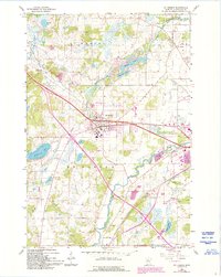
1965 Map of St Joseph
USGS Topo · Published 1993About this map
St Joseph and the surrounding township landscapes are defined by the winding course of the Sauk River and a dense network of glacial lakes and wetlands. This mid-1960s environment shows a rural community organized around traditional landmarks, including numerous numbered rural schoolhouses such as School No 2004 and School No 1912. The presence of small family or community burial grounds like Stranger Cem and Staples Cem provides specific points of interest for genealogical research in Stearns County.
Find a feature on this map
28 named features on this map. Tap any name to fly to it.
Don’t see what you’re looking for? This feature index may not catch every label — zoom into the map to look around manually.
Map Details
Editions of this 1965 St Joseph Map
5 editions found
Other maps of this area

1950 · St. Cloud
USGS Topo · 1:62,500

1951 · Annandale
USGS Topo · 1:62,500

1953 · Saint Cloud
USGS Topo · 1:250,000

1957 · Saint Cloud
USGS Topo · 1:250,000

1958 · Saint Cloud
USGS Topo · 1:250,000

1965 · St Stephen
USGS Topo · 1:24,000

1965 · Holdingford
USGS Topo · 1:24,000

1965 · St Joseph
USGS Topo · 1:24,000

1965 · Avon
USGS Topo · 1:24,000

1967 · Cold Spring
USGS Topo · 1:24,000