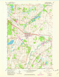
1965 Map of St Joseph
USGS Topo · Published 1982About this map
The Sauk River winds through the southern reaches of this landscape, joined by the complex drainage of the North Fork Watab River and South Fork Watab River to the north. At the heart of the region sits St Joseph, a significant rail point along the Great Northern tracks. To the west, the settlement of Collegeville and the crossroads at Five Points anchor the rural community. The area is dotted with numerous small lakes such as Watab Lake and Kraemer Lake, alongside evidence of local industry in several Quarry and Gravel Pit operations. Genealogists will find particular value in the presence of several country schoolhouses, including School No 2004 and School No 1912, and traditional burial grounds like Staples Cem and Stranger Cem, which offer a clear view of the social geography of the mid-1960s.
Find a feature on this map
28 named features on this map. Tap any name to fly to it.
Don’t see what you’re looking for? This feature index may not catch every label — zoom into the map to look around manually.
Map Details
Editions of this 1965 St Joseph Map
5 editions found
Other maps of this area

1950 · St. Cloud
USGS Topo · 1:62,500

1951 · Annandale
USGS Topo · 1:62,500

1953 · Saint Cloud
USGS Topo · 1:250,000

1957 · Saint Cloud
USGS Topo · 1:250,000

1958 · Saint Cloud
USGS Topo · 1:250,000

1965 · St Stephen
USGS Topo · 1:24,000

1965 · Holdingford
USGS Topo · 1:24,000

1965 · St Joseph
USGS Topo · 1:24,000

1965 · Avon
USGS Topo · 1:24,000

1967 · Cold Spring
USGS Topo · 1:24,000