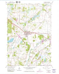
1965 Map of St. Joseph
USGS Topo · Published 1980About this map
St Joseph serves as the central hub of this Stearns County landscape, where the Great Northern railroad cuts a direct line through the prairie and woodland. The map documents a rural transition in the mid-1960s, punctuated by numerous localized industry sites such as the many Gravel Pits and a Quarry near the Sauk River. To the northwest, the community of Collegeville stands near the North Fork Watab River, while several numbered schoolhouses, including School No 1919 and School No 2004, indicate the persistent structure of early twentieth-century rural school districts. Water defines the edges of the quadrangle, from Watab Lake and Rossier Lake in the north to Pleasant Lake and the marshy expanse of Mud Lake in the south. Genealogists may find value in the precise locations of Stranger Cem and Staples Cem along the river bends.
Find a feature on this map
26 named features on this map. Tap any name to fly to it.
Don’t see what you’re looking for? This feature index may not catch every label — zoom into the map to look around manually.
Map Details
Editions of this 1965 St. Joseph Map
5 editions found
Other maps of this area

1950 · St. Cloud
USGS Topo · 1:62,500

1951 · Annandale
USGS Topo · 1:62,500

1953 · Saint Cloud
USGS Topo · 1:250,000

1957 · Saint Cloud
USGS Topo · 1:250,000

1958 · Saint Cloud
USGS Topo · 1:250,000

1965 · St Stephen
USGS Topo · 1:24,000

1965 · Holdingford
USGS Topo · 1:24,000

1965 · St Joseph
USGS Topo · 1:24,000

1965 · Avon
USGS Topo · 1:24,000

1967 · Cold Spring
USGS Topo · 1:24,000