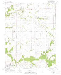
1964 Map of St. Libory
USGS Topo · Published 1966About this map
The agricultural divide between St Clair and Washington Counties is captured here in the mid-1960s, showing a landscape defined by small rural hubs and meandering waterways. St Libory and Darmstadt anchor the northern reaches, while the growth of Marissa is evident in the south, positioned near the earlier settlement of Old Marissa. The drainage patterns of Little Mud Creek and the South Fork of Mud Creek dictate the local topography, with wooded bottomlands contrasting against the rectilinear grid of township roads.
Find a feature on this map
21 named features on this map. Tap any name to fly to it.
Don’t see what you’re looking for? This feature index may not catch every label — zoom into the map to look around manually.
Map Details
Editions of this 1964 St. Libory Map
2 editions found
Other maps of this area

1910 · Okawville
USGS Topo · 1:62,500

1912 · New Athens
USGS Topo · 1:62,500

1912 · Baldwin
USGS Topo · 1:62,500

1914 · Baldwin
USGS Topo · 1:62,500

1914 · Coulterville
USGS Topo · 1:62,500

1917 · Coulterville
USGS Topo · 1:62,500

1940 · Okawville
USGS Topo · 1:62,500

1942 · Baldwin
USGS Topo · 1:62,500
1954 · Mascoutah
USGS Topo · 1:24,000
1954 · New Athens East
USGS Topo · 1:24,000