
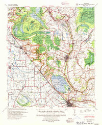
1939 Map of St. Martinsville
USGS Topo · Published 1946About this map
The winding course of Bayou Teche defines the economic and cultural heart of this Cajun landscape, flowing through the historic centers of St. Martinsville and New Iberia. In the late 1930s, this region shows a transition from traditional plantation life to modern infrastructure, seen in the proximity of Longfellow Evangeline State Park to the emerging St Martinsville Oil Field. The landscape is a network of waterways and early transport lines, including the Southern Pacific railroad and the Ruth Canal, which serviced the agricultural interests surrounding Spanish Lake. Local genealogy is well-represented through numerous schools and religious sites like the Mt Olive Ch & Cem and Cecelia Ch & Sch, alongside family-named holdings such as the Girouard Ranch. The topography reveals the complex drainage patterns of the area, including Cypress Island and various coulees that fed the local irrigation systems.
Find a feature on this map
85 named features on this map. Tap any name to fly to it.
Don’t see what you’re looking for? This feature index may not catch every label — zoom into the map to look around manually.
Map Details
Editions of this 1939 St. Martinsville Map
2 editions found
Other maps of this area

1932 · Abbeville NE
USGS Topo · 1:31,680

1935 · Osca Bayou
USGS Topo · 1:62,500

1937 · Jeanerette
USGS Topo · 1:62,500

1937 · Derouen
USGS Topo · 1:62,500

1940 · Arnaudville
USGS Topo · 1:62,500

1941 · Loreauville
USGS Topo · 1:62,500

1945 · New Orleans
USGS Topo · 1:250,000

1946 · Milton
USGS Topo · 1:31,680

1946 · Lafayette
USGS Topo · 1:31,680

1952 · Lake Charles
USGS Topo · 1:250,000