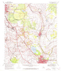
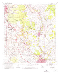
1970 Map of St. Martinville
USGS Topo · Published 1972About this map
Bayou Teche winds through the heart of Acadiana, connecting the historic centers of St Martinville and New Iberia in this 1970 snapshot of South Louisiana. The landscape is defined by the complex water systems of the Atchafalaya Basin edge, including Spanish Lake and the Evangeline Canal. This era shows the region's transition into a modern industrial and transportation hub, evidenced by the Cypress Island Gas Field and the sprawling Acadiana Regional Airport south of Cade. Cultural landmarks such as Longfellow-Evangeline State Park and the Holy Name Institute reflect the deep-rooted heritage of the Teche country. The map captures the dense network of small communities and rail sidings along the Southern Pacific and Missouri Pacific lines, from Broussard to the agricultural reaches of Segura and Morbihan.
Find a feature on this map
54 named features on this map. Tap any name to fly to it.
Don’t see what you’re looking for? This feature index may not catch every label — zoom into the map to look around manually.
Map Details
Editions of this 1970 St. Martinville Map
2 editions found
Other maps of this area

1932 · Abbeville NE
USGS Topo · 1:31,680

1935 · Osca Bayou
USGS Topo · 1:62,500

1937 · Jeanerette
USGS Topo · 1:62,500

1937 · Derouen
USGS Topo · 1:62,500

1939 · St. Martinsville
USGS Topo · 1:62,500

1940 · Arnaudville
USGS Topo · 1:62,500
1941 · Loreauville
USGS Topo · 1:62,500

1945 · New Orleans
USGS Topo · 1:250,000

1946 · Milton
USGS Topo · 1:31,680
1946 · Lafayette
USGS Topo · 1:31,680