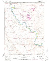
1961 Map of Stevens Flat
USGS Topo · Published 1981About this map
The Green River carves a winding path through the arid high country of Sweetwater County, anchoring a landscape where industrial utility meets conservation. In the northern reaches of this 1961 survey, the Seedskadee National Wildlife Refuge provides a protected corridor for the river's riparian habitat. Downstream, the environment shifts toward industry and transportation, marked by the prominent tracks of the Union Pacific railroad and a nearby Chemical Plant complete with its own substation and Filtration Plant. This transition highlights the river's dual role as both an ecological sanctuary and a vital resource for the region's infrastructure.
Find a feature on this map
23 named features on this map. Tap any name to fly to it.
Don’t see what you’re looking for? This feature index may not catch every label — zoom into the map to look around manually.
Map Details
Editions of this 1961 Stevens Flat Map
4 editions found
Other maps of this area

1954 · Rock Springs
USGS Topo · 1:250,000

1958 · Rock Springs
USGS Topo · 1:250,000

1961 · Blue Point
USGS Topo · 1:24,000

1961 · Little America
USGS Topo · 1:24,000

1961 · Peru
USGS Topo · 1:24,000

1961 · Austin Ranch
USGS Topo · 1:24,000

1961 · Stevens Flat
USGS Topo · 1:24,000

1961 · Bryan
USGS Topo · 1:24,000

1962 · Rock Springs
USGS Topo · 1:250,000

1963 · Big Island Bridge
USGS Topo · 1:24,000