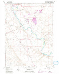
1961 Map of Stevens Flat
USGS Topo · Published 1992About this map
The Green River meanders through this high desert corridor, carving a green path through the arid expanse of Stevens Flat and Manns Flat. In the early 1960s, this landscape shows a distinct transition from traditional livestock operations to industrial development and conservation. Remote outposts like Pal Ranch and Hofeldt Ranch represent the region's ranching roots, while a modern Chemical Plant, Substation, and Filtration Plant signal the mid-century industrialization of Sweetwater County's resources.
Find a feature on this map
24 named features on this map. Tap any name to fly to it.
Don’t see what you’re looking for? This feature index may not catch every label — zoom into the map to look around manually.
Map Details
Editions of this 1961 Stevens Flat Map
4 editions found
Other maps of this area

1954 · Rock Springs
USGS Topo · 1:250,000

1958 · Rock Springs
USGS Topo · 1:250,000

1961 · Blue Point
USGS Topo · 1:24,000

1961 · Little America
USGS Topo · 1:24,000

1961 · Peru
USGS Topo · 1:24,000

1961 · Austin Ranch
USGS Topo · 1:24,000

1961 · Stevens Flat
USGS Topo · 1:24,000

1961 · Bryan
USGS Topo · 1:24,000

1962 · Rock Springs
USGS Topo · 1:250,000

1963 · Big Island Bridge
USGS Topo · 1:24,000