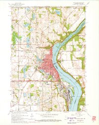
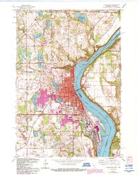
1967 Map of Stillwater
USGS Topo · Published 1975About this map
The St Croix River serves as the central artery of this 1967 revision, defining the border between Minnesota and Wisconsin. On the western bank, the city of Stillwater is shown with its dense residential and commercial core, featuring the prominent Courthouse and Lakeview Hospital. Further south along the shoreline, the Minnesota State Prison and the industrial activity of Bayport highlight the region's institutional and economic footprint. The landscape transitions from these riverfront hubs to a lake-dotted interior where bodies of water like Lake McKusick, Lily Lake, and Silver Lake are interspersed with several family-named burial grounds including Boutwell Cem and Rutherford Cem. Across the Interstate Bridge, the settlement of Houlton and its Drive-in Theater represent the early postwar expansion on the Wisconsin side, while the Chicago and North Western rail line traces the river's path, connecting these communities to the wider regional rail network.
Find a feature on this map
65 named features on this map. Tap any name to fly to it.
Don’t see what you’re looking for? This feature index may not catch every label — zoom into the map to look around manually.
Map Details
Editions of this 1967 Stillwater Map
5 editions found
Other maps of this area

1946 · Hudson
USGS Topo · 1:62,500

1946 · River Falls
USGS Topo · 1:62,500

1948 · New Richmond
USGS Topo · 1:62,500

1948 · Stillwater
USGS Topo · 1:62,500

1949 · New Richmond
USGS Topo · 1:62,500

1949 · River Falls
USGS Topo · 1:62,500

1949 · Hudson
USGS Topo · 1:62,500

1949 · Stillwater
USGS Topo · 1:62,500

1949 · Lake Elmo
USGS Topo · 1:24,000

1949 · Hudson
USGS Topo · 1:24,000