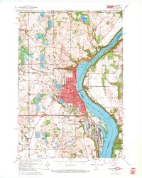
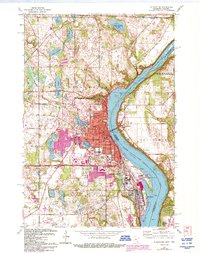
1967 Map of Stillwater
USGS Topo · Published 1969About this map
Lake St Croix and the St Croix River define the eastern boundary of this mid-century survey, separating Stillwater and Bayport in Minnesota from the Wisconsin shoreline at Houlton and North Hudson. The landscape is dotted with several notable burial grounds, including Fairview Cemetery, Boutwell Cem, and Rutherford Cem, which offer significant value for genealogical research in the St. Croix Valley. Further south, the prominent Minnesota State Prison complex stands near the riverbanks. The region's transport network is anchored by the Northern Pacific and Chicago and North Western railroads, which facilitated local industry such as the numerous Gravel Pits and the Quarry near Houlton. Residential growth is evident in Oak Park Heights and around inland water bodies like Lily Lake and Lake McKusick.
Find a feature on this map
59 named features on this map. Tap any name to fly to it.
Don’t see what you’re looking for? This feature index may not catch every label — zoom into the map to look around manually.
Map Details
Editions of this 1967 Stillwater Map
5 editions found
Other maps of this area

1946 · Hudson
USGS Topo · 1:62,500

1946 · River Falls
USGS Topo · 1:62,500

1948 · New Richmond
USGS Topo · 1:62,500

1948 · Stillwater
USGS Topo · 1:62,500

1949 · New Richmond
USGS Topo · 1:62,500

1949 · River Falls
USGS Topo · 1:62,500

1949 · Hudson
USGS Topo · 1:62,500

1949 · Stillwater
USGS Topo · 1:62,500

1949 · Lake Elmo
USGS Topo · 1:24,000

1949 · Hudson
USGS Topo · 1:24,000