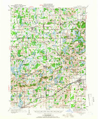
1919 Map of Stockbridge
USGS Topo · Published 1966About this map
The village of Stockbridge stands as a central hub in a landscape defined by an intricate network of glacial lakes and rural schoolhouses during the early twentieth century. This survey by C.H. Birdseye and his team reveals a transition from the agricultural plains of Ingham and Livingston counties into the varied topography of Lyndon and Waterloo. Local life is anchored by a dense distribution of one-room schools such as Stilson School, McIntee School, and Eaman School, illustrating the dispersed settlement patterns of the era.
Find a feature on this map
141 named features on this map. Tap any name to fly to it.
Don’t see what you’re looking for? This feature index may not catch every label — zoom into the map to look around manually.
Map Details
Editions of this 1919 Stockbridge Map
2 editions found

Other maps of this area

1902 · Dexter
USGS Topo · 1:62,500

1904 · Ann Arbor
USGS Topo · 1:125,000

1906 · Dexter
USGS Topo · 1:62,500

1906 · Saline
USGS Topo · 1:62,500

1907 · Howell
USGS Topo · 1:62,500

1908 · Ann Arbor
USGS Topo · 1:125,000

1908 · Fowlerville
USGS Topo · 1:62,500

1909 · Howell
USGS Topo · 1:62,500

1909 · Mason
USGS Topo · 1:62,500

1910 · Fowlerville
USGS Topo · 1:62,500