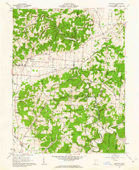
1961 Map of Stockdale
USGS Topo · Published 1962About this map
Stockdale serves as a central hub for this portion of Southern Ohio, situated at the junction of upland farms and the wooded ridges of the Wayne National Forest. The landscape is defined by the sharp transition from the broad valleys of the Scioto River and Little Scioto River to the deeply incised hollows of the hinterland. This era of the early 1960s highlights a rural community anchored by small country institutions, including the Madison School and numerous historic congregations such as Salem Church and Bethesda Church. Transport and industry are marked by the path of the C & O Railroad cutting through the terrain, alongside scattered extraction sites like the Gas Well near the Pike and Jackson county line. The map reveals a high density of family cemeteries and local landmarks, from Pools Corners to the Perry Addition, offering a clear view of the settlement patterns before modern consolidation altered the township structure.
Find a feature on this map
75 named features on this map. Tap any name to fly to it.
Don’t see what you’re looking for? This feature index may not catch every label — zoom into the map to look around manually.
Map Details
Editions of this 1961 Stockdale Map
2 editions found
Other maps of this area

1906 · Waverly
USGS Topo · 1:62,500

1908 · Waverly
USGS Topo · 1:62,500

1911 · Sciotoville
USGS Topo · 1:62,500

1912 · Oak Hill
USGS Topo · 1:62,500

1913 · Sciotoville
USGS Topo · 1:62,500

1913 · Jackson
USGS Topo · 1:62,500

1944 · Jackson
USGS Topo · 1:62,500

1947 · Columbus
USGS Topo · 1:250,000

1957 · Huntington
USGS Topo · 1:250,000

1960 · Huntington
USGS Topo · 1:250,000