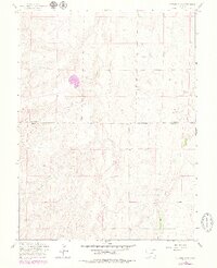
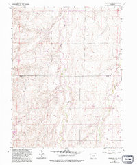
1961 Map of Strasburg SW
USGS Topo · Published 1979About this map
Kiowa Creek and Wolf Creek meander across this landscape, which reveals the transition between the high plains and the drainage systems of eastern Colorado. The terrain is characterized by a network of seasonal draws and ridges, reflecting a sparsely populated ranching and agricultural region during the early 1960s. Surveyed by the U.S. Corps of Engineers and updated with 1970s aerial photography, the map highlights the boundary between Arapahoe Co and Elbert Co. A small Gravel Pit indicates local land use and resource extraction in a territory otherwise defined by wide-open spaces. This edition captures the land's topographical nuances before modern development, preserving a view of the rural infrastructure and natural drainage patterns essential for local history and land-use studies.
Find a feature on this map
4 named features on this map. Tap any name to fly to it.
Don’t see what you’re looking for? This feature index may not catch every label — zoom into the map to look around manually.
Map Details
Editions of this 1961 Strasburg SW Map
5 editions found
Other maps of this area

1890 · East Denver
USGS Topo · 1:125,000

1894 · Castle Rock
USGS Topo · 1:125,000

1913 · Castle Rock
USGS Topo · 1:125,000

1939 · Elizabeth
USGS Topo · 1:62,500

1945 · Elizabeth
USGS Topo · 1:62,500

1953 · Denver
USGS Topo · 1:250,000

1954 · Watkins
USGS Topo · 1:24,000

1955 · Strasburg NW
USGS Topo · 1:24,000

1955 · Watkins SE
USGS Topo · 1:24,000

1955 · Strasburg
USGS Topo · 1:24,000