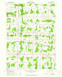
1961 Map of Sullivan
USGS Topo · Published 1963About this map
Sullivan and Homerville center this early 1960s landscape, where the agricultural traditions of Ashland and Medina counties meet the developing infrastructure of the mid-century. The terrain is defined by the West Fork Black River and Wellington Creek, with several small rural cemeteries like Gould Cem and Southview Cem marking the generational ties of local farming families. The era's industrial footprint is visible in the scattered Oil Wells and the crossing of major rail lines, including the Baltimore And Ohio Railroad and the New York Central And ST Louis Railroad. Educational consolidation is evident at the Black River High Sch, while the northern edge of the map features the recreational grounds of Findley State Park, providing a contrast to the dense network of county roads like Bursley Road and New London Eastern Road.
Find a feature on this map
41 named features on this map. Tap any name to fly to it.
Don’t see what you’re looking for? This feature index may not catch every label — zoom into the map to look around manually.
Map Details
Editions of this 1961 Sullivan Map
3 editions found
Other maps of this area

1904 · Wellington
USGS Topo · 1:62,500

1906 · Wellington
USGS Topo · 1:62,500

1906 · West Salem
USGS Topo · 1:62,500

1908 · Ashland
USGS Topo · 1:62,500

1908 · West Salem
USGS Topo · 1:62,500

1908 · New London
USGS Topo · 1:62,500

1950 · Marion
USGS Topo · 1:250,000

1956 · Toledo
USGS Topo · 1:250,000
1960 · Wellington
USGS Topo · 1:24,000

1960 · Nova
USGS Topo · 1:24,000