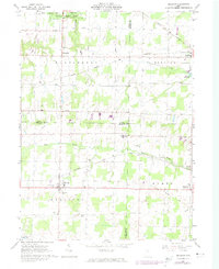
1961 Map of Sullivan
USGS Topo · Published 1974About this map
Huntington and Sullivan anchor this rural landscape within the historic Connecticut Western Reserve, where three counties—Ashland, Lorain, and Medina—converge. The region is defined by its transition from forest to field, with extensive Oil Wells scattered near the West Fork of the Black River. Significant infrastructure of the mid-20th century is evident, including the Baltimore and Ohio Railroad Grade and the Akron Canton and Youngstown Railroad crossing the terrain. For genealogists, the map preserves several local burial grounds such as Southview Cem, Gould Cem, and Marsh Cem. Educational and recreational life is centered around Black River High Sch and Findley State Park, which includes Findley Lake and a surrounding State Wildlife Area at the northern edge of the survey.
Find a feature on this map
39 named features on this map. Tap any name to fly to it.
Don’t see what you’re looking for? This feature index may not catch every label — zoom into the map to look around manually.
Map Details
Editions of this 1961 Sullivan Map
3 editions found
Other maps of this area

1904 · Wellington
USGS Topo · 1:62,500

1906 · Wellington
USGS Topo · 1:62,500

1906 · West Salem
USGS Topo · 1:62,500

1908 · Ashland
USGS Topo · 1:62,500

1908 · West Salem
USGS Topo · 1:62,500

1908 · New London
USGS Topo · 1:62,500

1950 · Marion
USGS Topo · 1:250,000

1956 · Toledo
USGS Topo · 1:250,000
1960 · Wellington
USGS Topo · 1:24,000

1960 · Nova
USGS Topo · 1:24,000