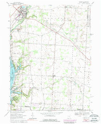
1967 Map of Sunbury
USGS Topo · Published 1988About this map
The village of Sunbury anchors the northwestern corner of this 1967 Delaware County survey, where the Penn Central rail line crosses Big Walnut Creek. The landscape transitions from the developed clusters in Galena and the newer residential layouts of the Maple Grove Trailer Park to the agricultural expanses of Trenton and Harlem townships. A significant portion of the western edge is defined by the Hoover Reservoir, with its normal pool elevation 890 and the adjacent Columbus City Park Boundary marking a major hydrological and recreational feature for the region.
Find a feature on this map
46 named features on this map. Tap any name to fly to it.
Don’t see what you’re looking for? This feature index may not catch every label — zoom into the map to look around manually.
Map Details
Editions of this 1967 Sunbury Map
3 editions found
Other maps of this area

1902 · Westerville
USGS Topo · 1:62,500

1904 · Westerville
USGS Topo · 1:62,500

1908 · Granville
USGS Topo · 1:62,500

1910 · Granville
USGS Topo · 1:62,500

1915 · Marengo
USGS Topo · 1:62,500

1915 · Fredericktown
USGS Topo · 1:62,500

1943 · Marengo
USGS Topo · 1:62,500

1943 · Fredericktown
USGS Topo · 1:62,500

1950 · Marion
USGS Topo · 1:250,000
1954 · Northeast Columbus
USGS Topo · 1:24,000