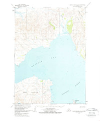
1963 Map of Sutwik Island C-6
USGS Topo · Published 1968About this map
Kujulik Bay dominates this coastal Alaska landscape, captured in the early 1960s. The map illustrates a remote maritime environment where human presence is marked by isolated sites like Kuju, Lik, and Julik along the western and northern shores. To the south, the prominent Cape Kumliun extends into the Pacific Ocean, flanked by Kumliun Creek and the small outpost of Easy. The cartography reveals a network of drainage systems, including Black Creek and the North Fork, which feed into the bay near various Cabin locations. This survey reflects the region's topography before extensive modern development, highlighting the distribution of small settlements and topographical landmarks such as Unavikshak Island and the nearby Shak site. The lack of established road networks underscores the reliance on coastal and air access typical of the Alaska Peninsula during this era.
Find a feature on this map
17 named features on this map. Tap any name to fly to it.
Don’t see what you’re looking for? This feature index may not catch every label — zoom into the map to look around manually.
Map Details
Editions of this 1963 Sutwik Island C-6 Map
2 editions found
Other maps of this area

1951 · Sutwik Island
USGS Topo · 1:250,000

1963 · Chignik B-1
USGS Topo · 1:63,360

1963 · Chignik C-1
USGS Topo · 1:63,360

1963 · Sutwik Island B-6
USGS Topo · 1:63,360

1963 · Sutwik Island
USGS Topo · 1:250,000

1963 · Sutwik Island C-6
USGS Topo · 1:63,360

1963 · Chignik
USGS Topo · 1:250,000
1963 · Sutwik Island C-5
USGS Topo · 1:63,360

1963 · Chignik D-1
USGS Topo · 1:63,360
1963 · Sutwik Island D-5
USGS Topo · 1:63,360