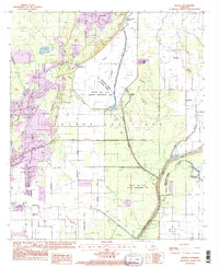
1994 Map of Swartz
USGS Topo · Published 1995About this map
Monroe Gas Field infrastructure defines the industrial character of this region northeast of Monroe, where a network of pipelines and gravel pits sits alongside the expansive Wham Brake. The landscape is a transition between the managed wetlands of the Russell Sage State Wildlife Management Area and the residential clusters of Swartz and Puckettville. This 1994 update reveals the intersection of conservation and industry, showing how natural water bodies like Alligator Lake and Little Bayou Boeuf are integrated with man-made levees and drainage ditches.
Find a feature on this map
43 named features on this map. Tap any name to fly to it.
Don’t see what you’re looking for? This feature index may not catch every label — zoom into the map to look around manually.
Map Details
Editions of this 1994 Swartz Map
This is the sole edition of this map. No revisions or reprints were ever made.
Other maps of this area

1935 · Collinston
USGS Topo · 1:62,500

1935 · Alto
USGS Topo · 1:62,500

1935 · Drew
USGS Topo · 1:62,500

1940 · Monroe
USGS Topo · 1:62,500

1955 · Jackson
USGS Topo · 1:250,000

1955 · Shreveport
USGS Topo · 1:250,000

1956 · Shreveport
USGS Topo · 1:250,000

1957 · Monroe North
USGS Topo · 1:62,500

1957 · Mangham
USGS Topo · 1:62,500

1957 · Monroe South
USGS Topo · 1:24,000