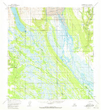
1954 Map of Talkeetna B-3
USGS Topo · Published 1972About this map
Chelatna Lake and the towering Kahiltna Glacier dominate this mid-century Alaskan landscape, where the braided channels of the Kahiltna River cut through an expanse of marsh and tundra. In the early 1950s, the isolated settlement at Collinsville and the Chelatna Lodge served as remote outposts for miners and hunters navigating the Peters Hills. The survey reveals a network of water-dependent transport and industry, from the gold-bearing potential of Dollar Creek and Hansen Bar Creek to the practical routes of the Tractor Trail.
Find a feature on this map
31 named features on this map. Tap any name to fly to it.
Don’t see what you’re looking for? This feature index may not catch every label — zoom into the map to look around manually.
Map Details
Editions of this 1954 Talkeetna B-3 Map
4 editions found
Other maps of this area

1950 · Talkeetna
USGS Topo · 1:250,000

1951 · Talkeetna
USGS Topo · 1:250,000

1954 · Talkeetna A-3
USGS Topo · 1:63,360

1954 · Talkeetna B-4
USGS Topo · 1:63,360

1954 · Talkeetna A-2
USGS Topo · 1:63,360

1954 · Talkeetna A-4
USGS Topo · 1:63,360

1954 · Talkeetna B-3
USGS Topo · 1:63,360

1954 · Talkeetna B-2
USGS Topo · 1:63,360

1958 · Talkeetna C-4
USGS Topo · 1:63,360

1958 · Talkeetna C-2
USGS Topo · 1:63,360