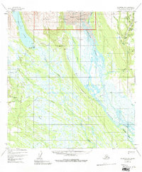
1954 Map of Talkeetna B-3
USGS Topo · Published 1981About this map
Chelatna Lake and the northern reaches of the Kahiltna River dominate this mid-century landscape in the Matanuska-Susitna region. Remote outposts like Chelatna Lodge and the small settlement at Collinsville appear alongside a network of Tractor Trails that provided essential overland access during the 1950s. The map illustrates the southern boundary of the Denali National Monument, where the Kahiltna Glacier feeds into a braided river system. Local nomenclature reflects the mining and trapping history of the area, with numerous water bodies like Cache Creek, Treasure Creek, and the humorously named Wetbutt Creek. Landmarks such as Hansen Bar and Sunset suggest a landscape defined by seasonal industry and isolation in the Alaskan interior before modern infrastructure arrived.
Find a feature on this map
27 named features on this map. Tap any name to fly to it.
Don’t see what you’re looking for? This feature index may not catch every label — zoom into the map to look around manually.
Map Details
Editions of this 1954 Talkeetna B-3 Map
4 editions found
Other maps of this area

1950 · Talkeetna
USGS Topo · 1:250,000

1951 · Talkeetna
USGS Topo · 1:250,000

1954 · Talkeetna A-3
USGS Topo · 1:63,360

1954 · Talkeetna B-4
USGS Topo · 1:63,360

1954 · Talkeetna A-2
USGS Topo · 1:63,360

1954 · Talkeetna A-4
USGS Topo · 1:63,360

1954 · Talkeetna B-3
USGS Topo · 1:63,360

1954 · Talkeetna B-2
USGS Topo · 1:63,360

1958 · Talkeetna C-4
USGS Topo · 1:63,360

1958 · Talkeetna C-2
USGS Topo · 1:63,360