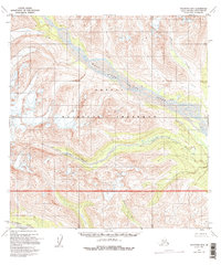
1958 Map of Talkeetna B-5
USGS Topo · Published 1995About this map
Denali National Preserve defines much of this interior Alaska landscape, where glacial waters and braided channels carve through the foothills of the Alaska Range. The massive drainage system of the West Fork Yentna River dominates the northern half of the sheet, joined by smaller tributaries like Cascade Creek as it flows southeast. Further south, the Fourth of July Creek and the Nakorhna River weave through steep contour intervals, illustrating the high-relief topography of the Matanuska-Susitna region. While largely uninhabited and noted as having no roads or trails in the area, a single Cabin along the Yentna River serves as a lone human landmark. This survey, compiled from 1950s aerial photography, provides a clear view of the Kichatna River valley before more modern conservation boundaries were formally established and revised.
Find a feature on this map
12 named features on this map. Tap any name to fly to it.
Don’t see what you’re looking for? This feature index may not catch every label — zoom into the map to look around manually.
Map Details
Editions of this 1958 Talkeetna B-5 Map
3 editions found
Other maps of this area

1950 · Talkeetna
USGS Topo · 1:250,000

1951 · Talkeetna
USGS Topo · 1:250,000

1954 · Talkeetna B-4
USGS Topo · 1:63,360

1954 · Talkeetna A-4
USGS Topo · 1:63,360

1958 · Talkeetna A-6
USGS Topo · 1:63,360

1958 · Talkeetna A-5
USGS Topo · 1:63,360

1958 · Talkeetna B-5
USGS Topo · 1:63,360

1958 · Talkeetna B-6
USGS Topo · 1:63,360

1958 · Talkeetna C-6
USGS Topo · 1:63,360

1958 · Talkeetna C-4
USGS Topo · 1:63,360