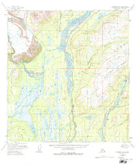
1958 Map of Talkeetna C-1
USGS Topo · Published 1975About this map
The Alaska Railroad provides the primary industrial spine through this Alaskan interior landscape, tracing the eastern bank of the Susitna River past the settlement of Curry. This region is defined by its massive glacial and river systems, where the Ruth Glacier feeds into the complex drainage of the Tokositna River and Chulitna River. The topography transitions from the broad, braided river valleys to the heights of Curry Ridge and the southern reaches of Denali State Park.
Find a feature on this map
27 named features on this map. Tap any name to fly to it.
Don’t see what you’re looking for? This feature index may not catch every label — zoom into the map to look around manually.
Map Details
Editions of this 1958 Talkeetna C-1 Map
5 editions found

Other maps of this area

1949 · Talkeetna Mountains D-6
USGS Topo · 1:63,360

1949 · Talkeetna Mountains B-6
USGS Topo · 1:63,360

1949 · Talkeetna Mountains C-6
USGS Topo · 1:63,360

1950 · Talkeetna Mountains
USGS Topo · 1:250,000

1950 · Talkeetna
USGS Topo · 1:250,000

1951 · Talkeetna
USGS Topo · 1:250,000

1951 · Talkeetna B-1
USGS Topo · 1:63,360

1951 · Talkeetna C-1
USGS Topo · 1:63,360

1951 · Talkeetna Mountains D-6
USGS Topo · 1:63,360

1952 · Talkeetna Mountains C-6
USGS Topo · 1:63,360