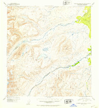
1952 Map of Talkeetna Mountains B-2
USGS Topo · Published 1953About this map
The Talkeetna Mountains define the high-altitude topography of this 1952 Alaskan interior survey, where a complex network of glacial-fed drainages carves through the landscape. This map illustrates the hydrology of the upper Susitna River basin shortly after aerial photography was first utilized to map the region in detail. The Oshetna River and Black River dominate the central drainages, with the latter originating from the isolated Black Lake. These waterways are fed by numerous high-elevation tributaries such as Gold Creek, Roaring Creek, and Granite Creek. The terrain is characterized by steep contours and prominent landmarks like Twin Hills, which rise between the river valleys. This map captures the area in its wilderness state, recording the natural watercourses and topography before modern resource development or expanded infrastructure reached this portion of the Third Judicial Division.
Find a feature on this map
11 named features on this map. Tap any name to fly to it.
Don’t see what you’re looking for? This feature index may not catch every label — zoom into the map to look around manually.
Map Details
Editions of this 1952 Talkeetna Mountains B-2 Map
2 editions found
Other maps of this area

1949 · Talkeetna Mountains A-1
USGS Topo · 1:63,360

1950 · Talkeetna Mountains
USGS Topo · 1:250,000

1951 · Talkeetna Mountains B-1
USGS Topo · 1:63,360

1951 · Talkeetna Mountains A-2
USGS Topo · 1:63,360

1951 · Talkeetna Mountains C-2
USGS Topo · 1:63,360

1951 · Talkeetna Mountains B-3
USGS Topo · 1:63,360

1951 · Talkeetna Mountains A-3
USGS Topo · 1:63,360

1951 · Talkeetna Mountains B-2
USGS Topo · 1:63,360

1951 · Talkeetna Mountains C-1
USGS Topo · 1:63,360

1951 · Talkeetna Mountains C-3
USGS Topo · 1:63,360