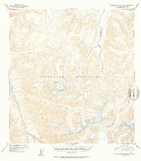
1952 Map of Talkeetna Mountains B-3
USGS Topo · Published 1953About this map
The Talkeetna Mountains define this high-altitude landscape in south-central Alaska, mapped here during a period of intensive aerial surveying in the early 1950s. The topography is dominated by an intricate drainage system where glacier-fed waters carve deep into the massif. Principal among these are the southward-flowing Kosina Creek and the westward-oriented Aspen Creek, both of which contribute to the larger Talkeetna River system.
Find a feature on this map
10 named features on this map. Tap any name to fly to it.
Don’t see what you’re looking for? This feature index may not catch every label — zoom into the map to look around manually.
Map Details
Editions of this 1952 Talkeetna Mountains B-3 Map
2 editions found
Other maps of this area

1949 · Talkeetna Mountains A-4
USGS Topo · 1:63,360

1950 · Talkeetna Mountains
USGS Topo · 1:250,000

1950 · Talkeetna Mountains B-4
USGS Topo · 1:63,360

1951 · Talkeetna Mountains A-2
USGS Topo · 1:63,360

1951 · Talkeetna Mountains C-2
USGS Topo · 1:63,360

1951 · Talkeetna Mountains B-3
USGS Topo · 1:63,360

1951 · Talkeetna Mountains A-3
USGS Topo · 1:63,360

1951 · Talkeetna Mountains B-2
USGS Topo · 1:63,360

1951 · Talkeetna Mountains C-4
USGS Topo · 1:63,360

1951 · Talkeetna Mountains C-3
USGS Topo · 1:63,360