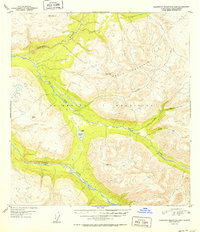
1952 Map of Talkeetna Mountains B-5
USGS Topo · Published 1952About this map
Talkeetna River and Sheep River carve through the high elevations of the Talkeetna Mountains in this early 1950s interior Alaska survey. The landscape is defined by its dramatic relief, reaching summits like Wells Mountain and the distinctively named Disappointment and Junto peaks. Settlement in this remote region is nearly nonexistent, represented only by isolated structures labeled as Cabin along the watercourses. The drainage patterns are highly detailed, showing the East Fork and Middle Fork feeding into Iron Creek, which eventually joins the larger river systems. A solitary body of water, Rainbow Lake, sits in a high basin between the primary river valleys. This map captures the topography of the Alaska wilderness shortly after the post-war aerial mapping efforts of 1949, documenting a primitive landscape before modern infrastructure reached deep into these mountain ranges.
Find a feature on this map
13 named features on this map. Tap any name to fly to it.
Don’t see what you’re looking for? This feature index may not catch every label — zoom into the map to look around manually.
Map Details
Editions of this 1952 Talkeetna Mountains B-5 Map
2 editions found
Other maps of this area

1949 · Talkeetna Mountains B-6
USGS Topo · 1:63,360

1949 · Talkeetna Mountains C-6
USGS Topo · 1:63,360

1949 · Talkeetna Mountains A-4
USGS Topo · 1:63,360

1950 · Talkeetna Mountains
USGS Topo · 1:250,000

1950 · Talkeetna Mountains B-5
USGS Topo · 1:63,360

1950 · Talkeetna Mountains B-4
USGS Topo · 1:63,360

1950 · Talkeetna Mountains A-6
USGS Topo · 1:63,360

1950 · Talkeetna Mountains A-5
USGS Topo · 1:63,360

1950 · Talkeetna Mountains C-5
USGS Topo · 1:63,360

1951 · Talkeetna Mountains C-4
USGS Topo · 1:63,360