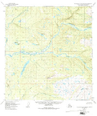
1949 Map of Talkeetna Mountains B-6
USGS Topo · Published 1975About this map
The Talkeetna River and its braided channels dominate this 1949 survey of the Matanuska-Susitna region, where the river system meets the Sheep River in a complex network of waterways. The landscape transition is marked by prominent high points such as Bald Mountain and VABM 2491 Sheep, while the surrounding terrain is dotted with significant water bodies including Larson Lake, Sockeye Lake, and the whimsically named Mama Bear Lake and Papa Bear Lake. Evidence of human presence is sparse in this era, noted only by an isolated Cabin near Chunilna Creek. The drainage patterns are clearly defined by the North Fork Montana Creek and Middle Fork Montana Creek in the southern portion of the quadrangle, illustrating the intricate watershed that feeds the Susitna Valley before significant modern development reached this interior wilderness.
Find a feature on this map
20 named features on this map. Tap any name to fly to it.
Don’t see what you’re looking for? This feature index may not catch every label — zoom into the map to look around manually.
Map Details
Editions of this 1949 Talkeetna Mountains B-6 Map
4 editions found
Other maps of this area

1949 · Talkeetna Mountains B-6
USGS Topo · 1:63,360

1949 · Talkeetna Mountains C-6
USGS Topo · 1:63,360

1950 · Talkeetna Mountains
USGS Topo · 1:250,000

1950 · Talkeetna
USGS Topo · 1:250,000

1950 · Talkeetna Mountains B-5
USGS Topo · 1:63,360

1950 · Talkeetna Mountains A-6
USGS Topo · 1:63,360

1950 · Talkeetna Mountains A-5
USGS Topo · 1:63,360

1950 · Talkeetna Mountains C-5
USGS Topo · 1:63,360

1951 · Talkeetna
USGS Topo · 1:250,000

1951 · Talkeetna B-1
USGS Topo · 1:63,360