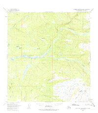
1949 Map of Talkeetna Mountains B-6
USGS Topo · Published 1975About this map
The Talkeetna River and Sheep River converge in a sprawling drainage system within the Matanuska-Susitna region, as documented by aerial photography from 1949. This wilderness landscape is defined by its complex hydrology, where glacial melt and seasonal runoff feed a network of family-named water bodies like Mama Bear Lake and Papa Bear Lake. The presence of large interior basins such as Larson Lake and Sockeye Lake suggests a territory defined by seasonal migration and natural bounty, rather than permanent industrial or residential development.
Find a feature on this map
16 named features on this map. Tap any name to fly to it.
Don’t see what you’re looking for? This feature index may not catch every label — zoom into the map to look around manually.
Map Details
Editions of this 1949 Talkeetna Mountains B-6 Map
4 editions found
Other maps of this area

1949 · Talkeetna Mountains B-6
USGS Topo · 1:63,360

1949 · Talkeetna Mountains C-6
USGS Topo · 1:63,360

1950 · Talkeetna Mountains
USGS Topo · 1:250,000

1950 · Talkeetna
USGS Topo · 1:250,000

1950 · Talkeetna Mountains B-5
USGS Topo · 1:63,360

1950 · Talkeetna Mountains A-6
USGS Topo · 1:63,360

1950 · Talkeetna Mountains A-5
USGS Topo · 1:63,360

1950 · Talkeetna Mountains C-5
USGS Topo · 1:63,360

1951 · Talkeetna
USGS Topo · 1:250,000

1951 · Talkeetna B-1
USGS Topo · 1:63,360