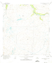
1951 Map of Talkeetna Mountains C-2
USGS Topo · Published 1973About this map
The Susitna River carves through the northern reaches of this Alaskan landscape, documented through aerial photography in the late 1940s. The terrain is defined by a dense network of drainage systems, including the headwaters of Gilbert Creek and Goose Creek. While largely devoid of permanent settlements, a solitary Cabin near the head of Twin Cr indicates the presence of trappers, hunters, or early explorers in this remote region. Survey markers like VABM 5603 Goose and VABM 4192 Windus serve as primary navigational anchors among the unnamed peaks. Central to the sheet, Clarence Lake sits as a significant water body, with VABM 3603 Clarence overlooking its basin. This 1951 edition provides a clear record of the area's natural state before any significant modern infrastructure or road classification reached this part of the Talkeetna Mountains.
Find a feature on this map
10 named features on this map. Tap any name to fly to it.
Don’t see what you’re looking for? This feature index may not catch every label — zoom into the map to look around manually.
Map Details
Editions of this 1951 Talkeetna Mountains C-2 Map
3 editions found
Other maps of this area

1950 · Talkeetna Mountains
USGS Topo · 1:250,000

1951 · Talkeetna Mountains B-1
USGS Topo · 1:63,360

1951 · Talkeetna Mountains C-2
USGS Topo · 1:63,360

1951 · Talkeetna Mountains B-3
USGS Topo · 1:63,360

1951 · Talkeetna Mountains D-2
USGS Topo · 1:63,360

1951 · Talkeetna Mountains B-2
USGS Topo · 1:63,360

1951 · Talkeetna Mountains C-1
USGS Topo · 1:63,360

1951 · Talkeetna Mountains D-1
USGS Topo · 1:63,360

1951 · Talkeetna Mountains D-3
USGS Topo · 1:63,360

1951 · Talkeetna Mountains C-3
USGS Topo · 1:63,360