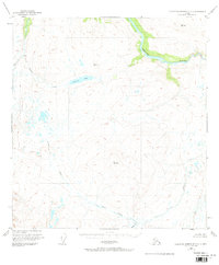
1951 Map of Talkeetna Mountains C-2
USGS Topo · Published 1973About this map
The Susitna River carves through this northern landscape, flowing westward toward a sharp southern bend. Surveyed just after mid-century, the area remains largely undeveloped, characterized by glacial drainage patterns and high-elevation survey markers like Vabm 5603 Goose and Vabm 4192 Windus. A lone Cabin situated east of Clarence Lake provides the only evidence of human habitation or shelter in this vast interior reach.
Find a feature on this map
10 named features on this map. Tap any name to fly to it.
Don’t see what you’re looking for? This feature index may not catch every label — zoom into the map to look around manually.
Map Details
Editions of this 1951 Talkeetna Mountains C-2 Map
3 editions found
Other maps of this area

1950 · Talkeetna Mountains
USGS Topo · 1:250,000

1951 · Talkeetna Mountains B-1
USGS Topo · 1:63,360

1951 · Talkeetna Mountains C-2
USGS Topo · 1:63,360

1951 · Talkeetna Mountains B-3
USGS Topo · 1:63,360

1951 · Talkeetna Mountains D-2
USGS Topo · 1:63,360

1951 · Talkeetna Mountains B-2
USGS Topo · 1:63,360

1951 · Talkeetna Mountains C-1
USGS Topo · 1:63,360

1951 · Talkeetna Mountains D-1
USGS Topo · 1:63,360

1951 · Talkeetna Mountains D-3
USGS Topo · 1:63,360

1951 · Talkeetna Mountains C-3
USGS Topo · 1:63,360