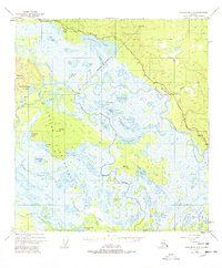
1948 Map of Tanacross A-3
USGS Topo · Published 1978About this map
The Tetlin Indian Reservation dominates this 1948 landscape, capturing a vast network of wetlands and river systems in eastern Alaska before significant modern development. The Tanana River meanders across the terrain, joined by the Kalukna River and Tetlin River amidst a complex of hundreds of lakes, including Midway Lake and the distinctive Nuziamundcho Lake. Evidence of early transportation and infrastructure is visible via the Alaska Highway in the north and a Pipeline corridor, while a Winter Sled Trail suggests the seasonal nature of movement through these wetlands.
Find a feature on this map
39 named features on this map. Tap any name to fly to it.
Don’t see what you’re looking for? This feature index may not catch every label — zoom into the map to look around manually.
Map Details
Editions of this 1948 Tanacross A-3 Map
4 editions found
Other maps of this area

1948 · Tanacross A-3
USGS Topo · 1:63,360

1948 · Tanacross A-4
USGS Topo · 1:63,360

1948 · Tanacross B-3
USGS Topo · 1:63,360

1949 · Tanacross
USGS Topo · 1:250,000

1949 · Tanacross B-4
USGS Topo · 1:63,360

1949 · Tanacross B-3
USGS Topo · 1:63,360

1950 · Tanacross
USGS Topo · 1:250,000

1950 · Nabesna
USGS Topo · 1:250,000

1951 · Nabesna
USGS Topo · 1:250,000

1951 · Tanacross B-4
USGS Topo · 1:63,360