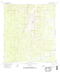
1956 Map of Tanacross C-3
USGS Topo · Published 1973About this map
Mount Fairplay dominates the central landscape of this interior Alaskan territory, where the terrain is marked by distinctive permafrost features like Pingos and smaller Pingo mounds. The Taylor Highway snakes through the western portion of the quadrangle, serving as the primary corridor for movement during the mid-1950s. Historically, this region has balanced seasonal accessibility with permanent land use, evidenced by the presence of a lone Cabin and the network of Winter Trails that connect remote drainages. The Dennison Fork and Cabin Creek provide the primary drainage system for the mountainous slopes, illustrating the relationship between high-altitude topography and the river-and-trail systems essential for interior travel. The map, based on 1954 aerial photography, captures a moment of early infrastructure development in a largely unpopulated wilderness.
Find a feature on this map
8 named features on this map. Tap any name to fly to it.
Don’t see what you’re looking for? This feature index may not catch every label — zoom into the map to look around manually.
Map Details
Editions of this 1956 Tanacross C-3 Map
3 editions found
Other maps of this area

1948 · Tanacross B-3
USGS Topo · 1:63,360

1949 · Tanacross
USGS Topo · 1:250,000

1949 · Tanacross B-4
USGS Topo · 1:63,360

1949 · Tanacross B-3
USGS Topo · 1:63,360

1950 · Tanacross
USGS Topo · 1:250,000

1951 · Tanacross B-4
USGS Topo · 1:63,360

1952 · Tanacross B-3
USGS Topo · 1:63,360

1956 · Tanacross D-3
USGS Topo · 1:63,360

1956 · Tanacross D-2
USGS Topo · 1:63,360

1956 · Tanacross C-3
USGS Topo · 1:63,360