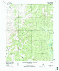
1956 Map of Tanana B-6
USGS Topo · Published 1974About this map
Gold Hill and the surrounding interior highlands define this mid-century survey of the Yukon-Koyukuk region. The landscape is marked by the presence of mineral extraction and early aviation, evidenced by a Placer Mine near Golden Creek and a remote Landing Strip tucked between the foothills of Lynx Dome and Grant Dome. These features indicate the early reach of prospecting and resource exploration into the Alaskan interior before modern infrastructure was established.
Find a feature on this map
29 named features on this map. Tap any name to fly to it.
Don’t see what you’re looking for? This feature index may not catch every label — zoom into the map to look around manually.
Map Details
Editions of this 1956 Tanana B-6 Map
2 editions found
Other maps of this area

1951 · Melozitna
USGS Topo · 1:250,000

1951 · Tanana
USGS Topo · 1:250,000

1952 · Tanana A-6
USGS Topo · 1:63,360

1952 · Tanana A-5
USGS Topo · 1:63,360

1952 · Melozitna A-1
USGS Topo · 1:63,360

1953 · Tanana A-5
USGS Topo · 1:63,360

1956 · Melozitna C-1
USGS Topo · 1:63,360

1956 · Melozitna B-1
USGS Topo · 1:63,360

1956 · Tanana B-5
USGS Topo · 1:63,360

1956 · Tanana B-6
USGS Topo · 1:63,360