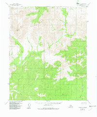
1956 Map of Tanana C-2
USGS Topo · Published 1982About this map
The Ray Mountains dominate this 1:63,360 scale survey of the Interior Alaska wilderness, showing a landscape defined by sharp drainage networks and high elevation benchmarks. High points such as Vabm Mt Tozi, Vabm McCormick, and Vabm Moose provide triangulation data for this remote stretch of the Yukon-Koyukuk region. The water system is particularly intricate, with the Tozitna River and Big Salt River cutting through the terrain, fed by numerous tributaries including Twilight Creek, Crash Creek, and the aptly named Canyon Creek.
Find a feature on this map
12 named features on this map. Tap any name to fly to it.
Don’t see what you’re looking for? This feature index may not catch every label — zoom into the map to look around manually.
Map Details
Editions of this 1956 Tanana C-2 Map
3 editions found
Other maps of this area

1951 · Tanana
USGS Topo · 1:250,000

1956 · Tanana B-1
USGS Topo · 1:63,360

1956 · Tanana C-1
USGS Topo · 1:63,360

1956 · Tanana D-2
USGS Topo · 1:63,360

1956 · Tanana B-2
USGS Topo · 1:63,360

1956 · Tanana D-3
USGS Topo · 1:63,360

1956 · Tanana C-3
USGS Topo · 1:63,360

1956 · Tanana B-3
USGS Topo · 1:63,360

1956 · Tanana C-2
USGS Topo · 1:63,360

1956 · Tanana D-1
USGS Topo · 1:63,360