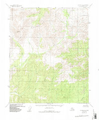
1956 Map of Tanana C-2
USGS Topo · Published 1988About this map
The Ray Mountains dominate this mid-century survey of the Alaskan interior, providing a detailed look at the drainage systems of the Tozitna River and Big Salt River. This is a landscape defined by its remote peaks and high-elevation survey markers, including Mt Tozi and the benchmarks VABM McCormick and VABM Moose. The absence of established roads or settlements highlights the wilderness character of the Yukon-Koyukuk region during the 1950s. Instead, the map traces a complex network of waterways such as Twilight Creek, Moose Creek, and the aptly named Roadhouse Creek, which hint at the historical travel routes used before modern infrastructure. These tributaries carve through the upland terrain, revealing the natural corridors that shaped early exploration and resource movement in the territory.
Find a feature on this map
12 named features on this map. Tap any name to fly to it.
Don’t see what you’re looking for? This feature index may not catch every label — zoom into the map to look around manually.
Map Details
Editions of this 1956 Tanana C-2 Map
3 editions found
Other maps of this area

1951 · Tanana
USGS Topo · 1:250,000

1956 · Tanana B-1
USGS Topo · 1:63,360

1956 · Tanana C-1
USGS Topo · 1:63,360

1956 · Tanana D-2
USGS Topo · 1:63,360

1956 · Tanana B-2
USGS Topo · 1:63,360

1956 · Tanana D-3
USGS Topo · 1:63,360

1956 · Tanana C-3
USGS Topo · 1:63,360

1956 · Tanana B-3
USGS Topo · 1:63,360

1956 · Tanana C-2
USGS Topo · 1:63,360

1956 · Tanana D-1
USGS Topo · 1:63,360