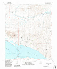
1950 Map of Teller B-3
USGS Topo · Published 1986About this map
Teller and Brevig Mission anchor the coastal landscape of this 1950 survey, positioned where the waters of Port Clarence meet Grantley Harbor. The map reveals a remote Seward Peninsula environment defined by seasonal movement and subsistence, marked by labels for Fish Camp and the Reindeer Camp (Site). A network of Winter Trails and standard Trails crisscross the tundra, connecting numerous Cabins scattered along waterways like Agiapuk River and Moonlight Creek. High points such as Red Mtn and Mukacharni Mountain rise above the complex drainage systems of the interior. The presence of a Ditch near Shelman Creek suggests historic water management for mining activities, while the Landing Strip at the mission and Light near Teller indicate the area's essential roles in regional transit and maritime navigation during the mid-20th century.
Find a feature on this map
51 named features on this map. Tap any name to fly to it.
Don’t see what you’re looking for? This feature index may not catch every label — zoom into the map to look around manually.
Map Details
Editions of this 1950 Teller B-3 Map
4 editions found
Other maps of this area

1950 · Teller
USGS Topo · 1:250,000

1950 · Teller A-2
USGS Topo · 1:63,360

1950 · Teller B-4
USGS Topo · 1:63,360

1950 · Teller B-2
USGS Topo · 1:63,360

1950 · Teller C-3
USGS Topo · 1:63,360

1950 · Teller A-3
USGS Topo · 1:63,360

1950 · Teller C-4
USGS Topo · 1:63,360

1950 · Teller A-4
USGS Topo · 1:63,360

1950 · Teller C-2
USGS Topo · 1:63,360

1950 · Teller B-3
USGS Topo · 1:63,360