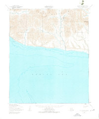
1950 Map of Teller B-5
USGS Topo · Published 1976About this map
The York Mountains dominate this rugged coastal stretch where the Continental Divide meets the Bering Sea. Industrial activity is centered on the Lost River Mine, supported by a Landing Strip and a cluster of Open cut mines and Quarries near Cassiterite Creek. The presence of these operations at the foot of Cassiterite Peak illustrates the mid-century mineral extraction efforts in this remote region. Transportation across the tundra is marked by a Winter Trail skirting the coast near Cape York, providing a tenuous link between drainage basins like the Kanauguk River and King River. Scattered features such as a Cabin and various Prospect sites indicate the sparse but persistent human footprint on a landscape otherwise defined by cold-water rivers like Philadelphia Cr and Oonateschuk Cr.
Find a feature on this map
23 named features on this map. Tap any name to fly to it.
Don’t see what you’re looking for? This feature index may not catch every label — zoom into the map to look around manually.
Map Details
Editions of this 1950 Teller B-5 Map
3 editions found
Other maps of this area

1950 · Teller
USGS Topo · 1:250,000

1950 · Teller B-4
USGS Topo · 1:63,360

1950 · Teller C-6
USGS Topo · 1:63,360

1950 · Teller C-4
USGS Topo · 1:63,360

1950 · Teller A-4
USGS Topo · 1:63,360
1950 · Teller B-5
USGS Topo · 1:63,360

1950 · Teller C-5
USGS Topo · 1:63,360
1950 · Teller B-6
USGS Topo · 1:63,360

1951 · Teller
USGS Topo · 1:250,000

1957 · Teller
USGS Topo · 1:250,000