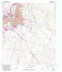
1965 Map of Temple
USGS Topo · Published 1993About this map
The rail-driven growth of Temple is clearly visible in this mid-century portrait, where the intersection of the Gulf Colorado and Santa Fe RR and the Missouri-Kansas-Texas RR defines the city's grid. The expansion of the medical community is already underway, centered on the Scott and White Hospital and the Olin E Teague Veterans Center. Moving away from the urban center toward the southeast, the landscape transitions into the rolling farmlands surrounding the community of Heidenheimer. Local history is preserved in several family and community burial grounds, including Greathouse Cem and Wedel Cem, while the natural drainage of the region is mapped through Bird Creek and Little Elm Creek. The survey captures the city just before major loop developments began to pull residential growth further from the historical downtown core.
Find a feature on this map
93 named features on this map. Tap any name to fly to it.
Don’t see what you’re looking for? This feature index may not catch every label — zoom into the map to look around manually.
Map Details
Editions of this 1965 Temple Map
3 editions found
Other maps of this area

1885 · Taylor
USGS Topo · 1:125,000

1887 · Taylor
USGS Topo · 1:125,000

1892 · Temple
USGS Topo · 1:125,000

1894 · Taylor
USGS Topo · 1:125,000

1924 · Temple 3-C
USGS Topo · 1:48,000

1924 · Temple 3-B
USGS Topo · 1:48,000

1931 · Belton
USGS Topo · 1:62,500

1954 · Waco
USGS Topo · 1:250,000

1954 · Austin
USGS Topo · 1:250,000

1955 · Waco
USGS Topo · 1:250,000