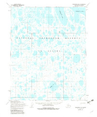
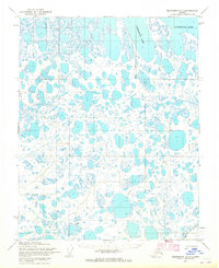
1955 Map of Teshekpuk B-2
USGS Topo · Published 1983About this map
The vast Arctic wetlands of the National Petroleum Reserve in Alaska dominate this mid-century survey, specifically the area south of the massive Teshekpuk Lake. The landscape is characterized by a dense network of thaw lakes and ponds, emphasizing the complex hydrology of the North Slope. Human presence is marked by isolated points such as Helen, Pat, Edna, Rice, Grace, and Draw, which likely represent survey markers or temporary camps rather than permanent settlements. Movement across this permafrost terrain is defined by seasonal routes, including a Tractor Tr and various winter-only paths. A notable detail for researchers of Arctic logistics is the designation of Thin (Impassable Ice) Winter routes, highlighting the navigational challenges in the frozen interior before reaching the southern reaches of Kealok Creek.
Find a feature on this map
13 named features on this map. Tap any name to fly to it.
Don’t see what you’re looking for? This feature index may not catch every label — zoom into the map to look around manually.
Map Details
Editions of this 1955 Teshekpuk B-2 Map
2 editions found
Other maps of this area

1951 · Teshekpuk
USGS Topo · 1:250,000

1955 · Teshekpuk
USGS Topo · 1:250,000
1955 · Teshekpuk A-2
USGS Topo · 1:63,360
1955 · Teshekpuk A-3
USGS Topo · 1:63,360
1955 · Teshekpuk B-3
USGS Topo · 1:63,360

1955 · Teshekpuk C-3
USGS Topo · 1:63,360

1955 · Teshekpuk A-1
USGS Topo · 1:63,360
1955 · Teshekpuk B-2
USGS Topo · 1:63,360

1955 · Teshekpuk B-1
USGS Topo · 1:63,360
1955 · Teshekpuk C-2
USGS Topo · 1:63,360