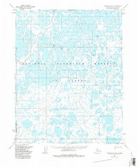
1955 Map of Teshekpuk B-3
USGS Topo · Published 1985About this map
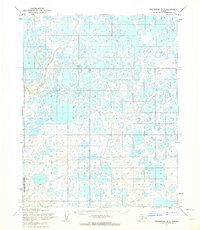
The Ikpikpuk River winds through the southwestern corner of this landscape, a region characterized by a dense network of lakes and marshes. Surveyed in the mid-1950s, this area is situated within the National Petroleum Reserve in Alaska, a designation reflecting the federal interest in the Arctic's energy potential during the Cold War era. Human presence is sparse, marked primarily by the industrial footprint of a single Drill Hole in the northeastern section and a Winter Trail that cuts across the northern tundra. These features suggest the seasonal nature of exploration and transit in the North Slope Borough, where movement depended heavily on the frozen ground of the winter months. The map meticulously records the complex hydrology of the coastal plain, showing the countless unnamed water bodies that define this part of the Alaskan wilderness.
Find a feature on this map
10 named features on this map. Tap any name to fly to it.
Don’t see what you’re looking for? This feature index may not catch every label — zoom into the map to look around manually.
Map Details
Editions of this 1955 Teshekpuk B-3 Map
2 editions found
Other maps of this area

1951 · Teshekpuk
USGS Topo · 1:250,000

1955 · Teshekpuk
USGS Topo · 1:250,000
1955 · Teshekpuk B-4
USGS Topo · 1:63,360
1955 · Teshekpuk A-2
USGS Topo · 1:63,360
1955 · Teshekpuk A-3
USGS Topo · 1:63,360
1955 · Teshekpuk B-3
USGS Topo · 1:63,360

1955 · Teshekpuk C-3
USGS Topo · 1:63,360
1955 · Teshekpuk B-2
USGS Topo · 1:63,360

1955 · Teshekpuk C-4
USGS Topo · 1:63,360
1955 · Teshekpuk A-4
USGS Topo · 1:63,360