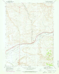
1968 Map of Thayer Junction
USGS Topo · Published 1978About this map
Thayer Junction serves as the focal point of this Sweetwater County landscape, where the Union Pacific railroad and early overland transport routes intersect. The map documents a rugged high-desert corridor defined by the drainage of Bitter Creek and Black Butte Creek. Traces of earlier industrial and migratory history are evident through the Old Railroad Grade winding through Horsethief Canyon and the Overland Trail, illustrating the evolution of Wyoming's transit infrastructure. Resource extraction is a primary feature of the era, with numerous drill holes, gas wells, and prospects scattered across the township. Local landmarks like the Salt Wells and the Superior Cem provide specific points of interest for genealogists and local historians, while the Pierotto Ditch suggests early efforts to manage water in this arid terrain.
Find a feature on this map
19 named features on this map. Tap any name to fly to it.
Don’t see what you’re looking for? This feature index may not catch every label — zoom into the map to look around manually.
Map Details
Editions of this 1968 Thayer Junction Map
2 editions found
Other maps of this area

1908 · Rock Springs
USGS Topo · 1:62,500

1910 · Rock Springs
USGS Topo · 1:62,500

1954 · Rock Springs
USGS Topo · 1:250,000

1958 · Rock Springs
USGS Topo · 1:250,000

1958 · Boars Tusk
USGS Topo · 1:62,500

1958 · Superior
USGS Topo · 1:62,500

1962 · Rock Springs
USGS Topo · 1:250,000

1968 · North Baxter
USGS Topo · 1:24,000

1968 · Point Of Rocks SW
USGS Topo · 1:24,000

1968 · Point Of Rocks
USGS Topo · 1:24,000