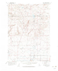
1957 Map of Thorn Creek
USGS Topo · Published 1959About this map
The Mount Bennett Hills dominate this high-desert landscape in south-central Idaho, where a complex network of water management features sustained the ranching and agricultural life of the mid-1950s. Multiple reservoirs, including McHan Reservoir, Thorn Creek Reservoir, and the Portuguese Reservoir, capture runoff from the drainages of Willow Creek and Thorn Creek. These water sources are vital in a terrain marked by numerous springs such as Mud Spring and Eureka Spr.
Find a feature on this map
69 named features on this map. Tap any name to fly to it.
Don’t see what you’re looking for? This feature index may not catch every label — zoom into the map to look around manually.
Map Details
Editions of this 1957 Thorn Creek Map
2 editions found
Other maps of this area

1949 · Gooding Butte
USGS Topo · 1:24,000

1950 · Gooding Butte
USGS Topo · 1:24,000

1955 · Twin Falls
USGS Topo · 1:250,000

1955 · Hailey
USGS Topo · 1:250,000

1957 · Fairfield
USGS Topo · 1:62,500

1957 · Thorn Creek SE
USGS Topo · 1:24,000

1957 · Thorn Creek SW
USGS Topo · 1:24,000

1957 · Thorn Creek
USGS Topo · 1:62,500

1957 · Davis Mountain
USGS Topo · 1:62,500

1957 · Bellevue
USGS Topo · 1:62,500