1932 Map of Tow
USGS Topo · Published 1949About this map
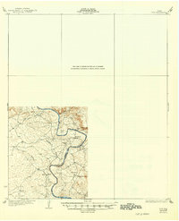
The Colorado River carves a deep, winding path through Central Texas in this mid-1920s survey, marking the boundary between Llano and Burnet counties. This era of the river's history is preserved here before the construction of massive hydroelectric dams significantly altered the landscape. The settlement of Bluffton serves as a local hub, supported by the Bluffton Sch and nearby OK School. Notable crossings and landmarks such as the Saltworks Ford and the unique riverside bend at Pearl Bend illustrate the rural transport patterns of the day. Terrain features like Baringer Hill and White Bluff dominate the topography, while tributary systems including Campground Creek and Bee Rock Creek feed into the primary river channel. The map provides a critical record of small family-based communities and topography that would soon be transformed by regional water management projects.
Find a feature on this map
14 named features on this map. Tap any name to fly to it.
Don’t see what you’re looking for? This feature index may not catch every label — zoom into the map to look around manually.
Map Details
Editions of this 1932 Tow Map
2 editions found

Other maps of this area

1885 · San Saba
USGS Topo · 1:125,000

1887 · Llano
USGS Topo · 1:125,000

1887 · Lampasas
USGS Topo · 1:125,000

1887 · Burnet
USGS Topo · 1:125,000

1893 · Burnet
USGS Topo · 1:125,000

1894 · Lampasas
USGS Topo · 1:125,000

1894 · San Saba
USGS Topo · 1:125,000

1894 · Llano
USGS Topo · 1:125,000

1903 · Burnet
USGS Topo · 1:125,000

1904 · Llano
USGS Topo · 1:125,000