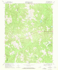
1969 Map of Trenholm
USGS Topo · Published 1971About this map
The borderlands of Cumberland Co Powhatan Co are defined by a network of winding waterways and rural crossroads during the late 1960s. Small community clusters such as Trenholm, Hatchers, and Belona anchor the landscape, which is marked by numerous country churches including Mt Moriah Ch and Little Zion Ch. The drainage patterns of Muddy Creek and Deep Creek influence the local topography, creating pockets of marshland like Maple Swamp and secluded water bodies such as Redford Pond.
Find a feature on this map
28 named features on this map. Tap any name to fly to it.
Don’t see what you’re looking for? This feature index may not catch every label — zoom into the map to look around manually.
Map Details
Editions of this 1969 Trenholm Map
3 editions found
Other maps of this area

1890 · Goochland
USGS Topo · 1:125,000

1891 · Palmyra
USGS Topo · 1:125,000

1891 · Farmville
USGS Topo · 1:125,000

1892 · Goochland
USGS Topo · 1:125,000

1893 · Farmville
USGS Topo · 1:125,000

1895 · Palmyra
USGS Topo · 1:125,000

1897 · Amelia
USGS Topo · 1:125,000

1897 · Palmyra
USGS Topo · 1:125,000

1943 · Goochland
USGS Topo · 1:31,680

1943 · Powhatan
USGS Topo · 1:31,680